Tsunami early warning
July 10, 2012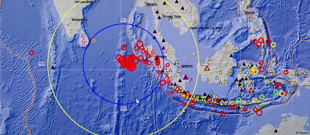
GITEWS (German Indonesian Tsunami Early Warning System) is a network made up of various types of sensors specifically designed to fit the geographical conditions in the Indian Ocean. Because the earthquake zone is not far from the coast, tsunami flood waves can reach shore as early as 30 to 40 minutes after a quake. That means the time needed to forecast a tsunami is quite short. In order to be able to react, experts depend on a combination of different technologies.
On land, there are 160 seismometers that measure activity in the earth's crust just under the Indian Ocean. GPS receivers measure the deformation of the earth's surface, 20 coastal stations monitor water levels. All the data is channeled to a central point - the warning center. There, a computer rapidly calculates in which direction a tsunami would go and how high its flood wall would be.
The early warning system was originally supposed to include 20 tsunami buoys. Each of them would have been as large as an advertising pillar and equipped with a GPS receiver, an anemometer, and a thermometer at a price of 250,000 euros ($310,000) each. They were also supposed to be connected with pressure sensors on the ocean floor. This would have measured the force and the changes in pressure caused by tsunami waves. The German Research Center for Geosciences (GFZ) had a contract for 10 buoys.
Buoys sent back
But the buoys proved to be of little use in Indonesia. Their signals came too late for an early warning system, fishermen used them to dock and their upkeep was simply too expensive. So they were taken out of the GITEWS project. Nonetheless, it is hoped that they might be used in future in other measuring systems in the open ocean.
In case of an emergency, GITEWS works like this: in the Sunda Straight, which is the most seismically active region off the coast of Indonesia, the ground shakes on the ocean floor. One to two minutes later, seismometers register the movement, and report the force and extent of it. Information from the seismographs, the GPS trackers and the coastal stations reaches a data center - the warning center - in the Indonesian capital city, Jakarta. There, experts wait around the clock to evaluate the data and decide whether or not to sound an alarm.
Five minutes after a quake of critical size is registered, experts aim at being able to either send out an alarm or an all-clear. In the case of a tsunami, that would give people in Indonesia - on the main islands, at least - around 30 minutes to get to high gound.
To help the experts evaluate the data, a computer program called SeisComP3 and created by the GFZ. The software compares incoming information with thousands of possible scenarios saved on the hard drive. But it is not the computer that decides whether or not a warning should be given. That is a decision made by the experts on duty.
Warnings are sent out into the most remote of villages via radio, TV and mobile text messages. The aim is to get a 50 percent success rate. It is not a modest goal; current warning systems have a much higher rate of false alarms.
Successful tests
The system was used to send out a warning twice now - once on September 12, 2007, when there was a series of big earthquakes off the coast of Sumatras. Although it has not yet been fully installed, GITEWS could locate movement on the ocean floor and calculate the magnitude. It would be able to send out a message to the warning center in Jakarta within five minutes - 20 minutes before a wave hits.
On April 11, 2012, two earthquakes, ranging from 8 to 9.0 on the Richter scale, were measured below the Indian Ocean. The warning chain kicked in and worked perfectly; but there was no wave. Luckily, the plates moved horizontally and not vertically like they did in the great tsunami of 2004.
Responsibility for the system has been in Indonesian hands since March, 2011. "But Germany continues to offer support, especially in training staff at the warning center," says GFZ chairman Reinhard Hüttl.
Emergency tsunami procedures have been planned right down to the evacuation of the coast in three test regions. But now, Indonesian authorities need to transfer that knowledge to the rest of the country.
Author: Frank Grotelüschen / sb
Editor: Gregg Benzow